blah blah blah
Mt. Tripyramid
Length: 11.2 miles out-and-back with loopDifficulty (click for info): Extreme
Elevation Gain: 3000 feet
Rating (click for info): 8/10
Elevation: 4159' (North), 4134' (Middle), and 4113' (South)
Prominence: 1360' (North), 287' (Middle), and 154' (South)
Driving Directions:
Trailhead and parking area are West Branch Road in Waterville Valley, NH. From Exit 28 on Rt. 93, drive 10.2 miles northeast on Rt. 49 and turn left onto Tripoli Road (signs for Waterville Valley Ski Area). In 1.2 miles, bear right to avoid the ski area entrance and continue 0.6 miles down Tripoli Road. Turn right onto West Branch Road, cross a bridge, and immediately bear left into the parking area. Click here for a Google map.
About the Hike:
The three peaks of Mt. Tripyramid are collectively one of the most distinct and easily recognizable mountains in the Whites. Limited views are found from the summits of North and Middle peaks (the two official 4000-footers), but the best views on this mountain by far are seen from its notorious landslides. This scenic loop hike includes both Tripyramid slides and the summit viewpoints. The Mt. Tripyramid Trail follows both slides for their entire length, and is consequently one of the most difficult hiking trails in New Hampshire. The North Tripyramid Slide in particular is dangerous in bad conditions, being the steepest hiking trail in the state, so you should exercise great care in planning for this hike. Consult other guides for different options for climbing the Tripyramids. If you're up for the challenge, press on and gain the immense enjoyment from the scenery and bragging rights!
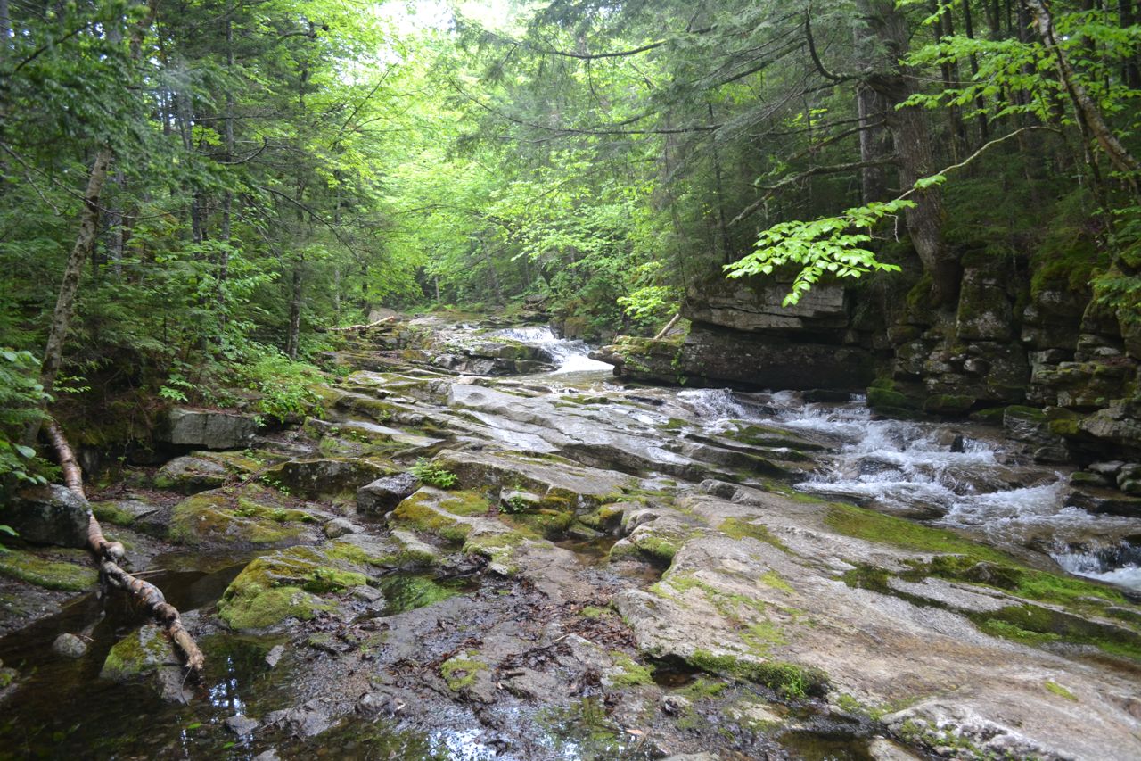
The hike to the Tripyramids begins with a long walk on the multi-use Livermore Trail, lined with small wildflowers in the spring. Start from the kiosk at the east end of the parking area and walk out to a junction. Turn left onto the flat, graded Livermore Trail, marked as Livermore Road on the cross-country ski trail signs. An easy walk of 0.3 miles leads out to a grassy clearing, where the tops of the three summits are in view over the treetops. Descend to pass another multi-use trail and cross a brook on a bridge, passing by Greeley Ponds Trail on the left. In a short distance, the trail crosses the Mad River on another bridge. Next, a quarter mile from the clearing, Boulder Path leaves on the right. The eponymous impressive boulder in Avalanche Brook, can be seen from the embankment on the side of Livermore Trail or by following Boulder Path up to the brook crossing. About 0.1 miles beyond, pass Big Pines Path on the left. This spur trail leads down to a stand of pine trees near the Mad River and will add 0.4 miles to your hike. In another 0.2 miles, pass Irene's Path on the left. Soon, the footway becomes sandy and leads gently uphill around a bend 0.2 miles into a meadow, climbing very gradually. 0.6 miles from the meadow, Norway Rapids Trail diverges to the right. You can follow this trail for 0.1 miles to view the trail's namesake, a fast-moving water slide up against a blocky ledge. This worthwhile detour is included in the mileage. Back on Livermore Trail, continue 0.4 miles and bear left where an old road crosses a bridge at a sign indicating the end of the ski trail system. The trail now begins to climb more noticeably and joins Avalanche Brook. 0.15 miles after the junction, herd paths lead down to the brook to access a scenic cascade and pool. The gradual ascent continues. In 0.3 miles from the cascade, the south end of Mt. Tripyramid Trail (where you will return) leads to the right, over Avalanche Brook. One more mile remains to the north end of this trail. Halfway through this section, the trail passes a clearing on the left at the site of one of the area's many historic logging camps.
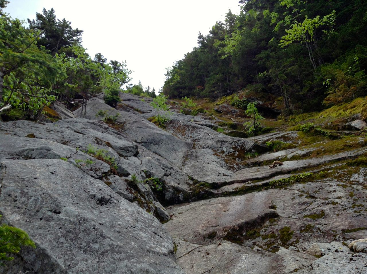
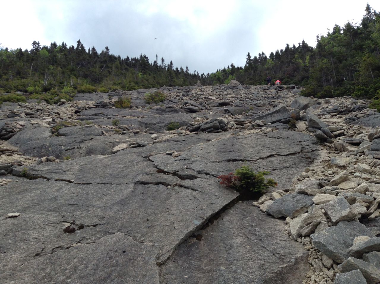
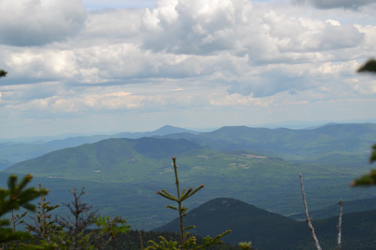
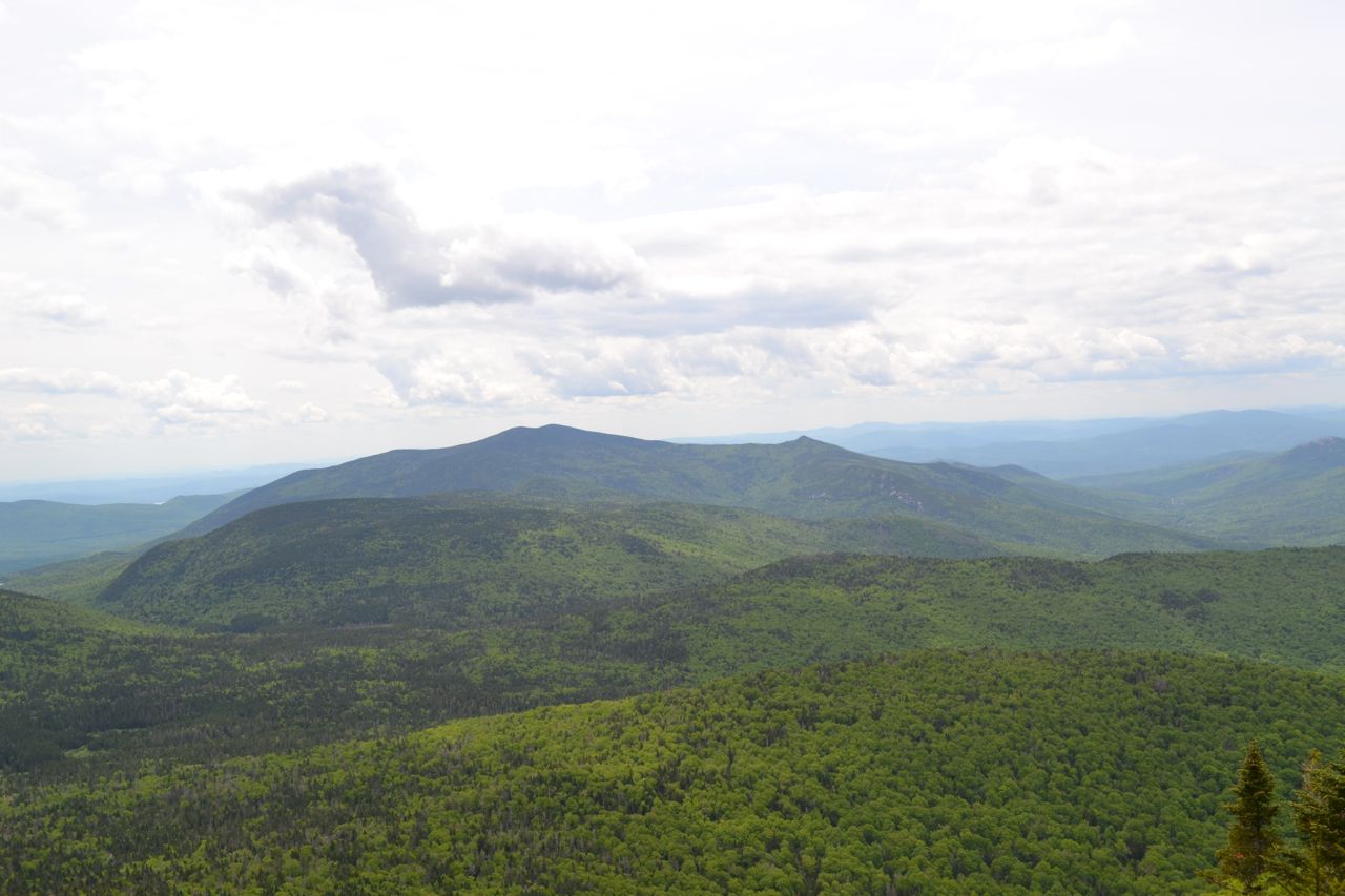
At a sharp left bend in Livermore Trail, turn right onto the much narrower Mt. Tripyramid Trail and descend abruptly to cross Avalanche Brook. It leads steeply up the bank on the other side, then turns across the slope to traverse above the brook. Climbing is still fairly gradual. Soon, it crosses the boundary of the Sandwich Range Wilderness. After 0.4 miles of up-and-down walking above the brook, the trail becomes steeper and turns right, soon reaching the gravel at the very bottom of the North Tripyramid Slide. The trail climbs more moderately over broken stone into the rocky gully and quickly becomes very steep. You'll need to stabilize yourself by holding on with your hands as you clamber up the lowest rock slabs. Soon, the center of the slide is overtaken by thick moss, and the trail diverges into the woods to the left of the slide. It climbs rapidly, and above the mossy section, empties hikers out onto the sheer ledge again. Choose your route carefully as you work your way up these most intimidating rock slabs, with no comforting trees to grab onto. As you gain elevation, views out toward the Thorton Gap region and the cliffs of Mt. Osceola start to open up, serving up a fine excuse to stop for a breath. Yet further up, the hardly visible pathway slides over to the left edge of the slide again and climbs up through the trees for a bit. Then the trail swings to the right and drops you back into the rocky gulch at the center of the slide. Watch for trail markings (mostly small cairns) carefully as the trail shifts from left to right. The surface of the slide now begins to transition into chunks of loose rock and gravel; stay on the left side for better footing on rock slabs, but cross to the right side before the slide forks. Aim for a large cairn at the very top. After much tedious climbing over sand and loose rock, reach the cairn. To the right of the cairn is a split boulder, perfect to rest on while you enjoy the spectacular view. To the far left is Mt. Tecumseh. Mt. Moosilauke rises over Thornton Gap between Tecumseh and Osceola; to the right of East Osceola are the Kinsmans. Next over is the Franconia Range, with the V-shaped Lincoln Slide prominently displayed. Next over, Mt. Garfield rises to left of the Twin Range, with Mt. Kancamagus in the foreground below. Closer and to the right are long Mt. Hancock, above Mts. Hitchcock and Huntington, and impressive Mt. Carrigain. Beyond Carrigain to the right is Mt. Willey, with the Nancy Range to the right of that. Furthest to the right is the Presidential Range.
Leaving the boulder, climb just a few feet to the top of the slide and turn left into the woods. In total, the slide was half a mile long. The steep climb continues through the forest for 0.1 mile to a trail junction. Turn right onto Mt. Tripyramid Trail/Pine Bend Brook Trail and reach the summit of North Tripyramid, where a spur leads left to a limited viewpoint to the northeast, looking at the Carter, Baldface, and Moat Ranges. The trail now descends from North Tripyramid and leads through the pleasant forest between North and Middle Peaks. Half a mile from the summit, Sabbaday Brook Trail enters from the left and Pine Bend Brook Trail ends. Continue ahead on Mt. Tripyramid Trail for a moderately steep 0.3 mile climb to Middle Tripyramid. Just before the summit, there is a good viewpoint to the west at Mt. Tecumseh and its ski area. At Middle Tripyramid's summit, you can peer over the trees to the east, in a slightly different direction than on the north park. You can see Mts. Chocorua and Passaconaway from here. Leaving the summit, the trail scrambles down a steep pitch in between two rock walls, then descends easily, passing an interesting rock cave. It runs flat for a short way, then climbs steeply up South Tripyramid, passing a very limited view back over the trail at North and Middle Peaks. The summit is reached half a mile from Middle Tripyramid. There is no view here.
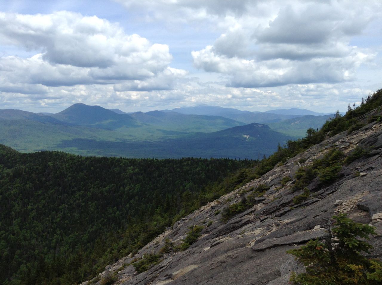
The trail crosses the high point around, then descends increasingly steeply toward the top of the south slide. A couple rock scrambles in the trees put you out in the open at the top of the always sunnier and more welcoming South Tripyramid Slide. Just below the top of the slide is a flat rock which provides a great place to sit and enjoy the view. There is a good view south to Lake Winnipesaukee and the Belknap Range. To the right of the lake is Red Hill, with Flat Mountain in front. Mt. Israel is seen to the right. Next over is Sandwich Dome, with a different Flat Mountain in front. Off to the far right are Welch and Dickey Mountains and Mt. Tecumseh. Just below your resting spot, Kate Sleeper Trail enters from the left at a new trail sign. The south slide is much easier than the north one and is more comfortable to descend. The recipe for this slide is loose gravel, with chunks of broken-off ledge mixed in, formed into occasional eroded gullies. You must plant your steps carefully, as it is quite easy to dislodge rocks, but the grade overall is not quite as steep as the north slide. Not too far down, the slide enters the woods, but still continues down very steeply, soon coming back out into the open. It passes a smooth boulder which invites climbing, and keeps going down steeply until it enters the forest again, where the pathway stays to the left of the gully. The slide soon ends, 0.4 miles from its apex, and the trail turns right and begins a gradual walk down through the forest. After about 0.45 miles, it approaches Slide Brook, which will be your companion for most of the way down from here. After 0.65 miles paralleling the brook, the trail passes Black Cascade, through the trees down an embankment. Some effort to climb down to the brook through the woods would be required if you really want to see the falls. Not far after this point, the trail crosses a tributary at a heavily washed out area. After another 0.4 miles, the trail pulls away from Slide Brook, running flat through an area that can be muddy. It crosses several minor streams before leaving the wilderness to cross Avalanche Brook, where it ends back at Livermore Trail in another 0.4 miles, 1.9 miles total from the base of the slide. Turn left and enjoy the easy walk back out the way you came.
Printable directions page